Species Detail - Amphibalanus improvisus - Species information displayed is based on the dataset "Water Framework Directive (WFD) Benthos Monitoring (Ireland) 2012 - ongoing".
Terrestrial Map - 10km
Terrestrial Map - 10km
Distribution of the number of records recorded within each 10km grid square (ITM).Marine Map - 50km
Marine Map - 50km
Distribution of the number of records recorded within each 50km grid square (WGS84).Species image
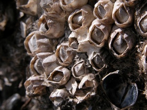
Amphibalanus improvisus
N/A
NHMSYS0021006588
RecommendedWell-formed
Invasive Species: Regulation S.I. 477/2011 (Ireland) || Invasive Species: Medium Risk Invasive Species (2013 Report) || Invasive Species: Regulation S.I. 374/2024 (Ireland)
amimp
(Darwin, 1854)
Crustacean
Species
1
1
1
27/07/2019
27/07/2019
12 July (recorded in 2025)
27 October (recorded in 2024)
Marine Institute, Water Framework Directive (WFD) Benthos Monitoring (Ireland) 2012 - ongoing, National Biodiversity Data Centre, Ireland, Amphibalanus improvisus, accessed 14 July 2026, https://maps.biodiversityireland.ie/Dataset/440/Species/280599