Species Detail - Amphibalanus improvisus - Species information displayed is based on the dataset "National Invasive Species Database".
Terrestrial Map - 10km
Terrestrial Map - 10km
Distribution of the number of records recorded within each 10km grid square (ITM).Marine Map - 50km
Marine Map - 50km
Distribution of the number of records recorded within each 50km grid square (WGS84).Species image
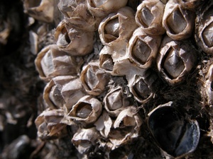
Amphibalanus improvisus
N/A
NHMSYS0021006588
RecommendedWell-formed
Invasive Species: Regulation S.I. 477/2011 (Ireland) || Invasive Species: Medium Risk Invasive Species (2013 Report) || Invasive Species: Regulation S.I. 374/2024 (Ireland)
amimp
(Darwin, 1854)
Crustacean
Species
2
2
2
01/01/2018
31/12/2022
12 July (recorded in 2025)
27 October (recorded in 2024)
Collated by the National Biodiversity Data Centre from different sources, National Invasive Species Database, National Biodiversity Data Centre, Ireland, Amphibalanus improvisus, accessed 07 July 2026, https://maps.biodiversityireland.ie/Dataset/397/Species/280599