Species Detail - Crangonyx pseudogracilis - Species information displayed is based on the dataset "A national macroinvertebrate dataset collected for the biomonitoring of Ireland’s river network, 2007–2018 (EPA)".
Terrestrial Map - 10km
Terrestrial Map - 10km
Distribution of the number of records recorded within each 10km grid square (ITM).Marine Map - 50km
Marine Map - 50km
Distribution of the number of records recorded within each 50km grid square (WGS84).Species image
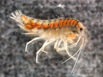
Crangonyx pseudogracilis
N/A
NBNSYS0000013808
UnverifiedUnverified
N/A
crpse
Bousfield, 1958
crustacean
Species
63
47
24
02/08/2012
15/09/2017
7 January (recorded in 1995)
1 December (recorded in 1990)
Environmental Protection Agency, A national macroinvertebrate dataset collected for the biomonitoring of Ireland’s river network, 2007–2018 (EPA), National Biodiversity Data Centre, Ireland, Crangonyx pseudogracilis, accessed 01 June 2025, <https://maps.biodiversityireland.ie/Dataset/335/Species/17466>