Species Detail - Crangonyx pseudogracilis - Species information displayed is based on the dataset "National Invasive Species Database".
Terrestrial Map - 10km
Terrestrial Map - 10km
Distribution of the number of records recorded within each 10km grid square (ITM).Marine Map - 50km
Marine Map - 50km
Distribution of the number of records recorded within each 50km grid square (WGS84).Species image
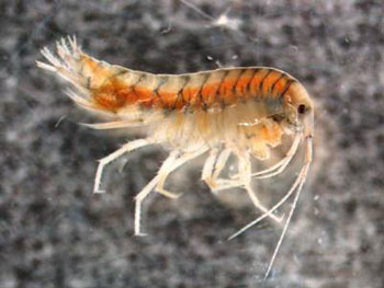
Crangonyx pseudogracilis
N/A
N/A
N/A
crpse
Bousfield, 1958
crustacean
Species
120
67
29
01/01/1983
26/11/2014
7 January (recorded in 1995)
1 December (recorded in 1990)
Collated by the National Biodiversity Data Centre from different sources, National Invasive Species Database, National Biodiversity Data Centre, Ireland, Crangonyx pseudogracilis, accessed 19 April 2024, <https://maps.biodiversityireland.ie/Dataset/66/Species/17466>